![]() Click to view this article in PDF format.
Click to view this article in PDF format.
Complex Structural Features of the Ardmore Basin*
By Robert W. Allen1
Search and Discovery Article #10027 (2002)
*Adapted for online presentation from an article, entitled “Stratigraphy, Mountain Building and Complex Geological Structures of the Ardmore Basin,” by the author and published by the Oklahoma City Geological Society in the Shale Shaker, v. 51, nos. 1, 2, and 3, July-December, 2000. Appreciation is expressed to the author and the Oklahoma City Geological Society (www.ocgs.org) for permission to present this online adaptation.
1Geologist, Ardmore, Oklahoma (tel-580-223-9367; fax-580-223-9368)
Editorial Note: Southern Oklahoma, in many respects, is a geological museum in that a wide range of structural styles, as well as stratigraphic regimes, exist in a geographically restricted area. Additionally, a significant part of the region has excellent subsurface data; for example, the Ardmore Basin, which rivals the richer hydrocarbon provinces in terms of petroleum produced per unit area. This presentation illustrates in cross-section a number of the structural features that are well documented because of the abundant well control and the readily recognizable stratigraphic units by expert stratigraphers. The author, with an unusually rich experience, is unparalleled in the ability to recognize, especially in samples, the Paleozoic stratigraphic units of the Ardmore Basin and environs. It is thought that these cross-sections may serve as models for features in complex structural areas with less well control and less certainty in identifying stratigraphic units.
A number of workers think that very significant strike-slip movement occurred along many of the major faults in Southern Oklahoma. Accordingly in most cases, the common reverse faults (in cross-section), generally referred to as thrust faults, would represent a minor component of the total displacement in a transpressive setting.
|
tStratigraphy, tectonic events
tStratigraphy, tectonic events
tStratigraphy, tectonic events
tStratigraphy, tectonic events
tStratigraphy, tectonic events
tStratigraphy, tectonic events
tStratigraphy, tectonic events
tStratigraphy, tectonic events
tStratigraphy, tectonic events
tStratigraphy, tectonic events
|
.
Click here for sequence of Figures 3, 4, 5, 6, 7, 8.
Click here for sequence of Figures 3, 4, 5, 6, 7, 8.
Click here for sequence of Figures 3, 4, 5, 6, 7, 8.
Click here for sequence of Figures 3, 4, 5, 6, 7, 8.
Click here for sequence of Figures 3, 4, 5, 6, 7, 8.
Click here for sequence of Figures 3, 4, 5, 6, 7, 8.
Study AreaThe area of study (Figure 1), some 4,750 square miles (T6S-T5N, R6W-R6E) in south-central Oklahoma, includes the Ardmore Basin as the central element. The surface features from south to north include the Criner Hills, Caddo Anticline, Arbuckle Mountains, Mill Creek Syncline, and Pauls Valley Uplift. In traditional terms, the Ardmore Basin lies between the Criner Hills and the Arbuckle Mountains, but it was more extensive before the Arbuckle Orogeny (Figures 2a and 2b; Figures 3, 4, 5, 6, 7, 8). In Figure 1, locations are identified of wells (1 through 7) that were used in determining a representative stratigraphic section and thicknesses for the units. These were utilized in preparing a series of cross-sections (from T5S,R1E to T2N,R5E--Figure 1) to illustrate depositional history and tectonism of the area.
Stratigraphy and Tectonic Events The samples from the seven wells located on Figure 1 were identified according to stratigraphic unit and thickness by Bronston W. James and the author.. In addition, Robert O. Fay, Oklahoma Geological Survey, identified and measured the thickness of each unit in the Arbuckle Mountains along I-35 highway. The results of these two studies (Figure 2b) show that there is a total stratigraphic section, Hoxbar to basement, of 31,845 feet. In this part of Oklahoma, basement rock is the Precambrian Tishomingo Granite, dated by radiometric methods as 1374 Ma. It crops out in T1-2S, R5-6E. This granite or equivalents are thought to underlie the entire study area (Figures 3, 4, 5, 6, 7, 8). Hamilton Brothers #1 Turner Falls well (see Figure 14) drilled through 15,840 feet of Cambrian stratiform igneous rocks (Carlton Rhyolite) before it penetrated carbonates of the Ordovician Arbuckle Group. The Upper Cambrian Reagan Sandstone overlies the rhyolite, and it in turn is overlain by the Honey Creek Limestone. The overlying Arbuckle Group, the Arbuckle is estimated to be 9,000 feet thick near the Criner Hills, some 6,700 feet thick in the Arbuckle Mountains, and about 5,000 feet thick in the Pauls Valley Uplift. Upper Ordovician to Devonian strata, which are an additional 3,900 feet in thickness, consist of the Simpson Group, Viola Limestone, Sylvan Shale, and Hunton carbonates. The first uplift of these rocks occurred during the Acadian Orogeny (Figure 2b), near the close of the Devonian. Pure #1 Resources Unit well (No. 5, Figure 1) drilled from the Woodford (Misener sand) to eroded Viola at 18,675 feet. The subsequent period of deposition was from the Devonian to Early Pennsylvanian (Figure 5). An additional 6,250 feet of sediments was deposited, with a total thickness at that time of 17,760 feet. The basin extended from the Criner Hills to the north side of the Pauls Valley Uplift. Each of the rock units Woodford, Sycamore, Caney, Springer, and Goddard, from oldest to youngest, has its own distinguishing characteristics. The Springer Formation, with its massive sands, has produced much oil and together with the Goddard has been responsible to a significant extent for ductile deformation (e.g., disharmonic folding), a common feature of the area. The Wichita Orogeny, which occurred after deposition of the Springer during Early Pennsylvanian, resulted in formation of the Criner Hills and the Pauls Valley Uplift (Figure 6). During Middle and Late Pennsylvanian (Figure 7), an additional 14,085 feet of sediments were deposited in this basin, with the total thickness of sedimentary rocks from Hoxbar to Granite being 31,845 feet. This youngest suite of sediments, oldest to youngest, are the Dornick Hills (Atokan and the Morrowan), Deese (Desmoinesian), and the Hoxbar formations. The Caddo Anticline and the Arbuckle Mountains formed during the Arbuckle Orogeny, following deposition of the Hoxbar Formation (Figure 8). The Hoxbar, Deese, and Dornick Hills sediments in the area between the Criner Hills to the south and the Pauls Valley Uplift to the north were complexly folded and faulted during the this orogeny. Representative Cross-sections Demonstrating Structural ComplexityA cross-section of the Ardmore Basin (Figure 9) extends from the South Palacine area, T2S, R6W, through Eola, T1N, R2W, to the Golden Trend, T2N, R2W (on the plunge of the Pauls Valley Uplift). The section shows major faulting, overturned beds (more commonly toward the northeast), and a thick sedimentary section. The cross-section of Eola Field (Figure 10) shows the Arbuckle formations, Reagan sandstone, and rhyolite (basement for sedimentary rocks) thrust over a gray shale (Deese) and Arbuckle units over synorogenic conglomerate, with the Deese unconformably overlying overturned Springer to Arbuckle beds. In effect, the major fault, dipping to the southwest, is under a buried part of the Arbuckle Mountains. Complex faulting and faulting in the Criner Hills area (Figure 11) are shown by the cross-section in Figure 12. It extends across Southwest Ardmore Field near the southeast end of the Criner Hills. Figure 13 is across Cottonwood Creek Oil Field, 10 miles west of Ardmore. This field produces from the Brown zone, the basal part of the West Spring Creek Formation of the Arbuckle Group. In the Continental #1 Smith (Figure 13), the Deese rests unconformably on the Viola, below which a normal section is present through the Brown zone. Older units are present above a fault, which in turn is above a repeated West Spring Creek Formation, including the Brown zone. Updip to the northeast in the downthrown fault block, the Brown zone is above an oil-water contact in a trap formed by beds farther to the northeast dipping in that direction. The section of Hoxbar, Deese, and Dornick Hills above the steeply dipping Pre-Pennsylvanian beds show relatively gentle dips, with onlap of the lower units to the southwest. Southeast Hoover Field (Area 3, Figure 14) also produces oil from the Brown zone well below gently dipping Permian rocks in a faulted, disharmonic anticline (Figure 15). At the west edge of the cross-section, the Oil Creek sand (Ordovician Simpson) is dipping steeply to the west. Just to the east, the Oil Creek is also present in the overturned limb of a syncline coupled with a thrust-faulted anticline. A well that encountered the fault, which dies out into the Oil Creek, contains approximately 1,600 feet of repeated section. The Basal Oil Creek sand, the Joins (Simpson), and the Arbuckle are not affected by this fault or the complex folding. The major reverse fault to the east shows 7,000 feet of vertical displacement of the Viola. Southwest Davis (Area 4, Figure 14), is an oil field that produces from the Basal Oil Creek sand. On outcrop of this sand just a few miles away, the sand is mined for its high quartz content. A portion of the electric log from Mapco #2 Howell is shown in Figure 16. At 3,700 feet, the sand is 60 feet thick, about half of its normal thickness. While following the instructions to drill 100 feet below the base of the sand, sample examination indicated that the Joins member of the Simpson was not being drilled--rather a thrust fault had been drilled and the Oil Creek section was repeated. Upon additional drilling, the Basal Oil Creek sand was drilled a second time at 4,080 feet. At this position, the sand was also saturated with oil, and the sand has a normal thickness of 140 feet. Further drilling found the Joins and the Arbuckle in a normal sequence. The electric log confirmed the sample descriptions that were logged during drilling. In this well this sand was above the oil-water contact in both fault blocks. The cross-section in the Southwest Davis Field (Figure 17) shows abnormal thickness of the Oil Creek formation, probably due in part to relatively minor faulting. One of the wells shows a repeated the Basal Oil Creek sand, with the sand in the downthrown block being below the oil-water contact. At the hairpin curve on U.S. 77, just 1/4 mile north of the Turner Falls overlook, the Washita Valley fault has juxtaposed massive gray Arbuckle limestone to the south and the Upper Pennsylvanian (or Permian) Collings Ranch Conglomerate overlying truncated, steeply dipping beds (Figure 18). The road cut along nearby I-35 shows a synclinal fold in the Collings Ranch Conglomerate. Arbuckle to Springer beds in the downthrown block are in a tightly folded syncline. Less than one mile to the south, the beds drilled (down to the Basal Oil Creek) in Placid #1 Geis well are exposed on the surface. In Southwest Sandy Creek Field (Area 6, Figure 14 and Figure 19), two miles east of Davis, Permian rocks unconformably overlie the Springer, which with the underlying strata are present in fault blocks bounded by four northeast-striking normal faults. Oil production from Bromide sand (Simpson) is in both the upthrown and downthrown blocks of each fault. The oil-water contact in each fault block is higher in the upthrown block toward the southeast. Other producing zones in Southwest Sandy Creek Field include the Sycamore, Woodford, Hunton, Viola, Basal McLish sand (Simpson) and Basal Oil Creek sand, all of which crop out in the Arbuckle Mountains a few miles to the south. In the cross-section of Figure 20, also from Southwest Sandy Creek Field area and approximately perpendicular to cross-section of Figure 19, tightly folded, complexly faulted strata are truncated by a thick Permian section. The abrupt change in structure to the northeast (from syncline to thrust-faulted anticline) corresponds to the boundary between the Mill Creek Syncline and the Pauls Valley Uplift (to the northeast), which formed during the Early Pennsylvanian Wichita Orogeny. Figure 21 shows the location of a cross-section of the Pauls Valley Uplift (Figure 22), with the Deese unconformably on the Caney Shale. To the east, this Wichita unconformity truncates older beds down to the lower part of the Viola. The unconformity now dips to the west. The Deese and Hoxbar thin to the east and onlap the unconformity.
Ham, W.E., M.E. McKinley, et al., 1954, Geologic map and sections of the Arbuckle Mountains, Oklahoma: Oklahoma Geological Survey, Map GM 31 (revised by K.S. Johnson, 1990). Harding, T.P.,1985, Seismic characteristics and identification of negative flower structures, positive flower structures, and positive structural inversion: AAPG Bull., v. 69, p. 582-600. Miser, H.D., 1954, Geologic map of Oklahoma: Oklahoma Geological Survey and U.S. Geological Survey. Parker, E.C., 1959, Structure and lithology of the Springer in Southeast Velma-Camp area, in Petroleum Geology of Southern Oklahoma, v. II: AAPG, p. 227-248. Reedy, H.J., and H.A. Sykes, 1959, Carter-Knox oil Field, Grady and Stephens counties, Oklahoma, in Petroleum Geology of Southern Oklahoma, v. II: AAPG, p. 198-219. S&D, 1999, Disharmonic folds in Southern Oklahoma: Revisited: Search and Discovery article #60004, v. 1, 1999 Schweers, F.P., 1959, Milroy Field, Stephens and Carter counties, Oklahoma, in Petroleum Geology of Southern Oklahoma, v. II: AAPG, p. 220-226. Tomlinson, C.W., 1952, Odd geologic structures in Southern Oklahoma: AAPG Bull., v.36, p. 1820-1840. Tomlinson, C.W., and William McBee, Jr., 1959, Pennsylvanian sediments and orogenies of Ardmore District, in Petroleum Geology of Southern Oklahoma, v. II: AAPG, p. 3-52. AcknowledgmentsA paper of this type requires the assistance of many friends. Bryan Sralla, a geologist who was in my office for five years and is currently employed with Coho Energy in Dallas, is an outstanding stratigrapher and structural geologist. Bryan supported and encouraged the preparation of this presentation. Charles Clarke, of Ardmore, Okla., is a good friend and an outstanding draftsman who helped with the original cross-sections and maps. Mike and Mary Allison of Gainesville, Texas, gave their support. Mike is an outstanding geologist and Mary constructed the original maps and cross-sections on her computer. The typing was done by Kathy Means, with Professional Office Services, of Ardmore, Okla. The paper was reviewed by Dr. Charles Gilbert, Professor of Geology and Geophysics at the University of Oklahoma, who provided input and suggestions; C. E. "Ed" Hannum, a friend and fellow geologist in Ardmore, who recommended that this be prepared as a scientific paper; Dr. Ray Brown, a geophysicist with the Oklahoma Geological Survey in Norman; Dr. Bob Neman, a good friend, fellow rock collector and chairman of the Department of Chemistry at East Central University, Ada, Oklahoma, and by Dr. Tommy Thompson, a consulting geologist and good friend from Boulder, Colo. Bob Northcutt, a friend and fellow geologist from Oklahoma City, heard this as a presentation and suggested it might be published in the Shale Shaker, the official publication of the Oklahoma City Geological Society. This information has been presented to the Ardmore Rotary Club, the Ardmore Optimist Club and to the geological societies in Ardmore, Oklahoma City and North Texas, as well as Tulsa. For a paper to be published, it needs professional attention. The Noble Foundation of Ardmore has this talent. My sincere thanks to Michael A. Cawley, president of the Noble Foundation, for his support; to Joe Lobell, Communications Department manager, for his consent; and to Sharon Burris, media and publications specialist, who put this paper in its final form. My sincere thanks to all. It is my hope that this information can be used by teachers, students, and anyone who might be interested in the subsurface geology of this fabulous planet on which we live. About the AuthorRobert W. "Bob" Allen, a native Oklahoman, is a professional geologist with over 50 years of geological experience. For the last 46 years Bob has lived and worked in Ardmore, Oklahoma studying the structure and stratigraphy of southern Oklahoma and prospecting for oil and gas. Bob's particular area of interest includes the surface and subsurface geology of the Arbuckle and Wichita Mountains, and the Ardmore and Marietta basins. Bob served in the U. S. Army during World War II from 1943 to 1946. Following his Army service he attended the University of Oklahoma where he earned a B.S. in Zoology in 1948 and a B.S. in Geology in 1950. After graduation from the University of Oklahoma, Bob worked for Globe Oil and Refining Company in Oklahoma City from 1949 until 1954 when he went to work for Continental Oil Company in Ardmore, Oklahoma. Bob was Division Geologist for the Southern Oklahoma Division of Continental Oil Company when he left them in 1962 to become an Independent and Consulting Geologist in Ardmore. Bob Allen has been a leader and staunch supporter in the preservation of the Ardmore Sample Cut and Library. Bob is a longtime member of the American Association of Petroleum Geologists, the Oklahoma City Geological Society, and the Ardmore Geological Society, who named him an Honorary Life Member in 1988. Return to top. |

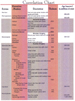 Figure 2a. Correlation chart for Ardmore
Basin.
Figure 2a. Correlation chart for Ardmore
Basin. Figure
2b. Estimated stratigraphic thickness, south-central Oklahoma; thickness
of Pennsylvanian Hoxbar to granite of 31,845 feet was used in this
study.
Figure
2b. Estimated stratigraphic thickness, south-central Oklahoma; thickness
of Pennsylvanian Hoxbar to granite of 31,845 feet was used in this
study. Figure 3. Generalized, diagrammatic
paleo-cross-section, Criner Hills / Ardmore Basin / Arbuckle Mountains /
Mill Creek Syncline / Pauls Valley Uplift, Middle Ordovician
Figure 3. Generalized, diagrammatic
paleo-cross-section, Criner Hills / Ardmore Basin / Arbuckle Mountains /
Mill Creek Syncline / Pauls Valley Uplift, Middle Ordovician Figure 4. Generalized, diagrammatic
paleo-cross-section, Criner Hills / Ardmore Basin / Arbuckle Mountains /
Mill Creek Syncline / Pauls Valley Uplift, Late Ordovician-Devonian
Figure 4. Generalized, diagrammatic
paleo-cross-section, Criner Hills / Ardmore Basin / Arbuckle Mountains /
Mill Creek Syncline / Pauls Valley Uplift, Late Ordovician-Devonian Figure 5. Generalized, diagrammatic
paleo-cross-section, Criner Hills / Ardmore Basin / Arbuckle Mountains /
Mill Creek Syncline / Pauls Valley Uplift, Early Pennsylvanian
Figure 5. Generalized, diagrammatic
paleo-cross-section, Criner Hills / Ardmore Basin / Arbuckle Mountains /
Mill Creek Syncline / Pauls Valley Uplift, Early Pennsylvanian Figure 6. Generalized, diagrammatic
paleo-cross-section, Criner Hills / Ardmore Basin / Arbuckle Mountains /
Mill Creek Syncline / Pauls Valley Uplift, Early Pennsylvanian, after
Wichita Orogeny
Figure 6. Generalized, diagrammatic
paleo-cross-section, Criner Hills / Ardmore Basin / Arbuckle Mountains /
Mill Creek Syncline / Pauls Valley Uplift, Early Pennsylvanian, after
Wichita Orogeny Figure 7. Generalized, diagrammatic
paleo-cross-section, Criner Hills / Ardmore Basin / Arbuckle Mountains /
Mill Creek Syncline / Pauls Valley Uplift, Late Pennsylvanian, after the
deposition of the Hoxbar; Deese and Dornick Hills
Figure 7. Generalized, diagrammatic
paleo-cross-section, Criner Hills / Ardmore Basin / Arbuckle Mountains /
Mill Creek Syncline / Pauls Valley Uplift, Late Pennsylvanian, after the
deposition of the Hoxbar; Deese and Dornick Hills Figure 8. Generalized, diagrammatic
paleo-cross-section, Criner Hills / Ardmore Basin / Arbuckle Mountains /
Mill Creek Syncline / Pauls Valley Uplift, Late Pennsylvanian, following
the Arbuckle Orogeny
Figure 8. Generalized, diagrammatic
paleo-cross-section, Criner Hills / Ardmore Basin / Arbuckle Mountains /
Mill Creek Syncline / Pauls Valley Uplift, Late Pennsylvanian, following
the Arbuckle Orogeny Figure 10. Cross-section, Southeast Eola Field, showing overturned beds,
major fault, and a thick Springer section in the center of syncline
Figure 10. Cross-section, Southeast Eola Field, showing overturned beds,
major fault, and a thick Springer section in the center of syncline Figure 11. Ardmore area map, with Criner Hills, showing locations of
cross-sections
Figure 11. Ardmore area map, with Criner Hills, showing locations of
cross-sections Figure 12. Cross-section, Southwest Ardmore Field, southeast Criner
Hills, showing tightly folded beds cut by high-angle reverse faults
Figure 12. Cross-section, Southwest Ardmore Field, southeast Criner
Hills, showing tightly folded beds cut by high-angle reverse faults Figure 13. Cross-section, Cottonwood Creek Oil Field, with major
unconformity across productive fold in downthrown block of reverse fault
Figure 13. Cross-section, Cottonwood Creek Oil Field, with major
unconformity across productive fold in downthrown block of reverse fault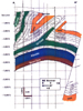 Figure 15. Southeast Hoover Oil Field, in upthrown block of major
reverse fault, showing disharmonic folds with local thrust fault
Figure 15. Southeast Hoover Oil Field, in upthrown block of major
reverse fault, showing disharmonic folds with local thrust fault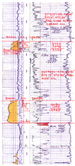 Figure 16. Part of electric log of Mapco
#7 Howell (NE NW SW NE sec. 14, T1S, R1E) in Southwest Davis Oil Field,
showing repetition of Ordovician Basal Oil Creek sand
Figure 16. Part of electric log of Mapco
#7 Howell (NE NW SW NE sec. 14, T1S, R1E) in Southwest Davis Oil Field,
showing repetition of Ordovician Basal Oil Creek sand Figure 17. Cross-section, Southwest
Davis Oil Field, showing anticlinal feature in downthrown block of the
reverse (thrust) fault (to the northeast), recognized by repetition of
the Basal Oil Creek sand in key wells
Figure 17. Cross-section, Southwest
Davis Oil Field, showing anticlinal feature in downthrown block of the
reverse (thrust) fault (to the northeast), recognized by repetition of
the Basal Oil Creek sand in key wells Figure
18. Cross-section, utilizing surface data, north flank of the Arbuckle
Mountains. This cross-section shows Washita Valley fault and the
vertical to overturned beds in the downthrown block along road cuts
Figure
18. Cross-section, utilizing surface data, north flank of the Arbuckle
Mountains. This cross-section shows Washita Valley fault and the
vertical to overturned beds in the downthrown block along road cuts
 Figure 20. Cross-section, Southwest Sandy Creek Field - Pauls Valley
Uplift, with the former lying southwest of faulted, tightly folded,
overturned syncline, which in turn is southwest of anticlinal feature in
the upthrown block of reverse fault bounding the uplift, all below a
major unconformity
Figure 20. Cross-section, Southwest Sandy Creek Field - Pauls Valley
Uplift, with the former lying southwest of faulted, tightly folded,
overturned syncline, which in turn is southwest of anticlinal feature in
the upthrown block of reverse fault bounding the uplift, all below a
major unconformity Figure 21. Location map of cross-section of Pauls Valley Uplift
 Figure
22. Cross-section of Pauls Valley Uplift
Figure
22. Cross-section of Pauls Valley Uplift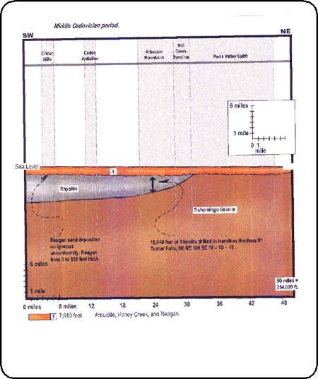