Click to view article in PDF format (~2.6 mb).
Salt Geology and New Plays in Deep-Water Gulf of Mexico*
By
Abu Chowdhury1 and Laura Borton1
Search and Discovery Article #10132 (2007)
Posted August 25, 2007
*Adapted from extended abstract prepared for AAPG Annual Convention, Long Beach, California, April 1-4, 2007
1TGS-NOPEC Geophysical Company, Houston, TX ([email protected])
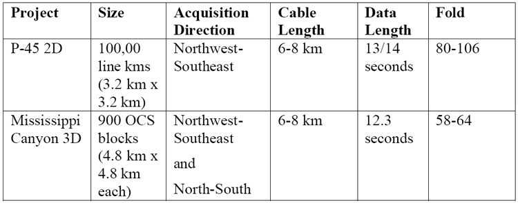
In deep-water Gulf of Mexico, two pre-stack depth migration projects were undertaken recently to better image the deep-water salt and sub-salt geology. The Phase 45 Too (P-45) survey area, stretching from Corpus Christi/Port Isabel in the west to Atwater Valley in the east, comprises approximately 100,000 line kilometers of 2D seismic data. It was pre-stack depth migrated and is currently being used for a deep-water interpretation project integrating approximately 1100 wells, including 300 biostratigrahic wells. In the Mississippi Canyon area, approximately 900 OCS blocks (4.8 km x 4.8 km each) of 3D seismic data were pre-stack depth migrated. More than 80 salt penetration wells were integrated in the Mississippi Canyon salt model interpretation project. The pre-stack depth migrated data identify autochthonous and allochthonous salt and associated archetypes. The autochthonous Jurassic Louann (mother) Salt, Jurassic sediments, and the overlying Cretaceous and Paleogene sequences are well manifested in the data sets. The new Lower Tertiary play is typically characterized by broad rollover structures created by the loading of sediments, deflation and withdrawal of the mother salt, and subsequent collapse of the sediments. The good imaging of the sedimentary section and folded structure below the salt helps delineate the new Lower Tertiary play, which has proven successful in many parts of the P-45 area, and can possibly be tested in Mississippi Canyon.
|
|
Salt and sediment interactions play a major role in producing reservoir rocks and traps for hydrocarbon accumulation in the Gulf of Mexico (GOM). Advanced seismic technology, specifically pre-stack depth migration, and deep-water wells drilled recently have provided better understanding of salt geology and new plays for hydrocarbon accumulations. This deepwater regional study extends from the Corpus Christi/Port Isabel protraction areas in the west, eastward to the Mississippi Canyon protraction area, northward to the shelf/slope break and southward to the US-Mexico border.
Two seismic pre-stack depth migrated data sets (Figure 1) were used to better understand the deep-water salt and associated geology. Phase 45 Too (P-45), a regional 2D project, integrated approximately 1100 wells, including 300 biostratigraphic wells, in the interpretation of salt and regional geology. Mississippi Canyon, a large 3D project, utilized a significant number of wells to enhance the velocity model for migration. The data sets are described below:
In both the P-45 and Mississippi Canyon projects, the top and base of salt were mapped during the pre-stack depth migration process, which is outlined below:
1. Sediment velocity model created by converting PSTM velocities to depth and removing salt velocities. 2. Pre-processed gathers migrated with sediment velocity model. 3. Top of salt interpreted based on its seismic signature of high amplitude, low frequency reflections, and diagnostic reflection geometries. 4. Salt-flood velocity model created by overlaying the top of salt interpretation on the sediment velocity model and flooding the volume below the top of salt with salt velocity. 5. Pre-processed gathers migrated with salt–flood velocity model. 6. Base of salt interpreted. 7. Final velocity model created by overlaying the top and base of salt interpretations on the sediment velocity model and filling the body with salt velocity. 8. Final migration. 9. Post-processing.
To aid in picking top and base of salt, water bottom and top of salt multiples were calculated and mapped to discriminate primary salt reflections from multiple reflections. In addition, depth gathers were analyzed for flatness as a quality control. In P-45, eight sequence boundaries from the lower Pliocene down to the Cretaceous were also mapped to decipher the geology. The sequence boundaries were picked based on the integrated interpretation of biostratigrahic data, well log stacking patterns, and seismic reflection patterns.
Regional Geology of Deep-Water Salt The salt in deep-water GOM varies in size and structural style compared to the shelf/slope salt. The allochthonous salt in the shelf/slope ranges from diapiric bodies to regional Roho salt structures to thin welds. Many of these salt features are associated with a regional decollement surface which can be traced to the shelf. The thickness of the majority of these salt structures varies from 0.2 km to 3 km, and the ratio of salt to sediment is approximately 30:70. The autochthonous root is rarely visible on the shelf. In contrast, the deep-water salt bodies are massive; they attain thicknesses up to 6 km in eastern Alaminos Canyon, Keathley Canyon, and Walker Ridge. Some salt bodies in Mississippi Canyon (Thunder Horse area) appear to be rooted and show thicknesses up to 8 km. The salt-sediment ratio in the deep-water GOM is approximately 60:40. The key regional structural elements, namely, the Perdido fold belt, Sigsbee salt canopy, and Atwater/Mississippi fold belt, are directly associated with salt tectonics. The northeast trending Perdido fold belt extends from the southern GOM into Alaminos Canyon. The folded sediments are composed of Upper Jurassic to Eocene rocks underlain by high relief Louann Salt autochthons. The Wilcox sands, deposited between the Upper Paleocene and the lower Eocene, establish the reservoir for the Lower Tertiary play. The fold belt terminates in Garden Banks where Plio-Pleistocene thick depocenters dominate. The east-northeast trending Mississippi/Atwater fold belt lies in and around the Atwater Valley protraction area and is composed of folded Upper Jurassic to Miocene sediments. Like the Perdido fold belt, the rocks are underlain by Louann Salt. However, it differs from the Perdido fold belt in that the reservoir rocks tested by most wells are Miocene in age. Overlying these fold belts is the large southward-moving Sigsbee salt sheet. This allochthonous canopy makes seismic imaging a challenge and drilling difficult.
Exploration in offshore Gulf of Mexico has advanced from amplitude plays in the shelf/slope environment to salt flank mini-basin plays on the slope to the new deep-water Lower Tertiary plays. The pre-stack depth migrated dip line in Figure 2 gives an example of the latter two plays. The sequences from the Pliocene (SA) (approximately 7 million years old) to the Mesozoic/Cretaceous (MZ) (approximately 70 million years old) are annotated on the section. Starting on the slope at Garden Banks on the left hand side of the section, four successful mini-basin discoveries (Auger, Macaroni, Magnolia, and Red Hawk) and their associated block and well numbers are shown. Continuing across the salt into deeper water in Walker Ridge, St. Malo shows the new frontier deep-water Lower Tertiary play. The varying salt geometries in the GOM discussed in the previous section can also be seen in Figure 2. The slope is primarily sediment with three allochthonous diapirs, ranging from 0.8 km to 3 km. As discussed, the autochthonous roots are hardly visible. In the deep-water, the section contains a large amount of salt, with a thickness up to 6 km. Figure 3 is a pre-stack depth migrated strike line across Walker Ridge and Atwater Valley that again shows the Lower Tertiary play and a Lower Miocene discovery. The sequences are the same as Figure 2. However, note on this section the Mesozoic/Cretaceous boundary is annotated with a “K”. Starting in Walker Ridge on the left hand side of the section (Figure 3), St. Malo is displayed, as it is in Figure 2. Crossing the Sigsbee escarpment, Chinook and Cascade, two successful Lower Tertiary prospects, are shown. Arriving in Atwater Valley, Neptune in the Atwater/Mississippi fold belt exhibits a Lower Miocene success. The recent discoveries, Jack #2 in Walker Ridge and Kaskida in Keathley Canyon, have proven the Lower Tertiary play to be continuous across the deep-water Gulf of Mexico from Alaminos Canyon in the west (e.g., Trident and Great White) to Walker Ridge in the east (e.g., Cascade and St. Malo). The pre-stack depth migrated seismic section in Figure 4 shows the Jack prospect. The sequence annotations are similar to those in Figures 2 and 3. The discovery and test wells and the frontier play between the Paleocene (P) and Eocene (E) geologic horizons are noted. The four Lower Tertiary wells, St. Malo, Cascade, Chinook, and Jack (Figures 2, 3, and 4) have each found significant amounts of oil. The reservoirs are the Wilcox sands in the Paleocene (PA/P) that are sandwiched between the Mesozoic/Cretaceous (MZ/K/M) and the Eocene (EO/E) sequences, and the closures are associated with salt-cored anticlines. Of special interest are the St. Malo well (Figures 2 and 3) and the Jack well (Figure 4), which penetrate approximately three kilometers and four kilometers of salt, respectively, before encountering their Lower Tertiary discoveries and reaching their total depths at the top of the Mesozoic. Although most literature has the eastern Lower Tertiary discovery boundary around Walker Ridge, data from Mississippi Canyon suggests that it may extend farther (Figure 5). This pre-stack depth migrated section shows the area around the Thunder Horse prospect and the BP well drilled to the Lower Miocene/Upper Oligocene. A rollover structure below total depth of the well is shown, and it is possible that the Lower Tertiary play that has been tested and proven to the west exists here.
The pre-stack seismic data used in this study clearly images salt geology and the new deep-water plays tested by wells. However, improved imaging of the Lower Tertiary beneath salt is still needed to improve hydrocarbon evaluation. Mississippi Canyon wells that have tested and produced from the Lower Miocene/Upper Oligocene reservoirs may have the potential for Lower Tertiary discoveries as well.
Suggested References Fiduk, Joseph C., Weimer, Paul, Trudgill, Bruce D., Rowan, Mark G., Gale, Peter, G., Gafford, William, T., Geneva R., Lowe, Roger, and Queffelec, Thomas, A., 1999, The Perdido Fold Belt, northwestern deep Gulf of Mexico: Part 2. Stratigraphy and petroleum systems: AAPG Bulletin, v. 83 p. 578-610. Meyer, Dave, Zarra, Larry, Rains, David, Meltz, Bob and Hall, Tom, 2005, Emergence of the Lower Tertiary Wilcox trend in the deepwater Gulf of Mexico: World Oil, May 2005, p. 72-77. Trudgill, Bruce D., Rowan, Mark G., Fiduk, Joseph C., Weimer, Paul, Gale, Peter E., Korn, Bryant E., Phair, Ronald L., Gafford, William T., Roberts, Geneva, R, and Dobbs, Steven W., 1999, The Perdido Fold Belt, northwestern deep Gulf of Mexico: Part 1. Structural geometry, evolution and regional implications: AAPG Bulletin, v. 83, p. 88-113.
We would like to thank TGS-NOPEC management for their support and permission to publish this paper. We also thank Ray Martin who has significant contribution to the interpretation of the data. |